


We help businesses save up to 85% in costs with flexible plans at reasonable prices, reducing the burden of high fees from international providers with comparable quality.

We continuously expand, standardize data, and improve features to promptly meet your needs.

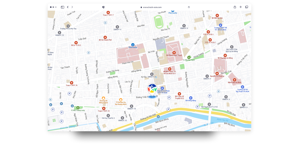
TrackAsia provides map API services suitable for most types of businesses in Vietnam.

We provide complete scenarios, sample examples, and APIs compatible with most popular map platforms today. This helps integrations happen quickly, with minimal time, and without fear of changes due to system impact or incompatibility with libraries in use.
Convert addresses to coordinates and vice versa, helping to accurately locate places on the map.
Service providing static (non-interactive) map images that you can embed into websites, emails, or apps.
Accurately suggest locations, even when there are abbreviation errors, spelling mistakes, or local language.
Service to calculate routes between points on the map, focusing on optimal travel routes.
A.I helps calculate distance and travel time between multiple origins and multiple destinations.
Cost optimization: Minimize total operating costs, including fuel costs and working time.
|
Query Count |
Under 200.000 |
200.001 to 500.000 |
500.001 to 1.000.000 |
Over 1.000.000 |
|---|---|---|---|---|
|
MapTiles |
0đ |
0đ |
1đ |
1đ |
|
Search / Autocomplete |
15đ |
14đ |
12đ |
10đ |
|
Geocoding / Reverse |
15đ |
14đ |
12đ |
10đ |
|
Routing / Distance |
17đ |
16đ |
15đ |
12đ |
|
VRP |
38đ |
36đ |
32đ |
28đ |
Supports exchanging geocode and router query ratios · Billing cycle based on usage days, no need to worry about when your plan starts


Volume Level
(1.000/queries)
Trackasia
Domestic API Map
LoadTiles / Mapview
Under 200.000đ
0đ
78.000đ
200.001đ - 500.000đ
0đ
71.500đ
500.001đ - 1.000.000đ
10.000đ
68.500đ
Search / Autocomplete / Geocoding / Reverse
Under 200.000đ
0đ
78.000đ
200.001đ - 500.000đ
0đ
71.500đ
500.001đ - 1.000.000đ
10.000đ
68.500đ
Routing / Distance Matrix
Under 200.000đ
0đ
78.000đ
200.001đ - 500.000đ
0đ
71.500đ
500.001đ - 1.000.000đ
10.000đ
68.500đ
Volume Level
(1.000/queries)
Trackasia
International API Map
LoadTiles / Mapview
Under 200.000đ
0đ
78.000đ
200.001đ - 500.000đ
0đ
71.500đ
500.001đ - 1.000.000đ
10.000đ
68.500đ
Search / Autocomplete / Geocoding / Reverse
Under 200.000đ
0đ
78.000đ
200.001đ - 500.000đ
0đ
71.500đ
500.001đ - 1.000.000đ
10.000đ
68.500đ
Routing / Distance Matrix
Under 200.000đ
0đ
78.000đ
200.001đ - 500.000đ
0đ
71.500đ
500.001đ - 1.000.000đ
10.000đ
68.500đ
Service
Volume Level
Trackasia
(1.000/queries)
Domestic API Map
(1.000/queries)
International API Map
(1.000/queries)
LoadTiles / Mapview
Under 200.000đ
0đ
78.000đ
78.000đ
LoadTiles / Mapview
200.001đ - 500.000đ
0đ
71.500đ
145.824đ
LoadTiles / Mapview
500.001đ - 1.000.000đ
10.000đ
68.500đ
145.824đ
Search / Autocomplete
Under 200.000đ
15.000đ
45.500đ
73.293đ
LoadTiles / Mapview
200.001đ - 500.000đ
14.000đ
34.500đ
59.911đ
LoadTiles / Mapview
500.001đ - 1.000.000đ
12.000đ
32.500đ
59.911đ
Geocoding / Reverse
Under 200.000đ
15.000đ
45.500đ
73.293đ
Geocoding / Reverse
200.001đ - 500.000đ
14.000đ
34.500đ
59.911đ
LoadTiles / Mapview
500.001đ - 1.000.000đ
12.000đ
32.500đ
59.911đ
Routing / Distance Matrix
Under 200.000đ
17.000đ
80.500đ
130.200đ
Routing / Distance Matrix
200.001đ - 500.000đ
16.000đ
70.500đ
104.160đ
Routing / Distance Matrix
500.001đ - 1.000.000đ
15.000đ
60.500đ
104.160đ
Includes services
 Geocoding API
Static Maps API
Autocomplete API
Routing API
Distance Matrix API
Geocoding API
Static Maps API
Autocomplete API
Routing API
Distance Matrix API
 Geo tool
Satellite
Geo tool
Satellite
Related support documents
Max zoom level 15
Navigation and satellite maps
Places / addresses / utilities / companies
Technical support 03 months
Includes services
Geocoding API
Static Maps API
Autocomplete API
Routing API
Distance Matrix API
Geo tool
Satellite
Related support documents
Max zoom level 16
Navigation and satellite maps
Places / addresses / utilities / companies
Technical support 03 months
Includes services
Geocoding API
Static Maps API
Autocomplete API
Routing API
Distance Matrix API
Geo tool
Satellite
Related support documents
Max zoom level 15
Navigation and satellite maps
Places / addresses / utilities / companies
Technical support 03 months
Includes services
Geocoding API
Static Maps API
Autocomplete API
Routing API
Distance Matrix API
Geo tool
Satellite
Related support documents
Max zoom level 16
Navigation and satellite maps
Places / addresses / utilities / companies
Technical support 03 months
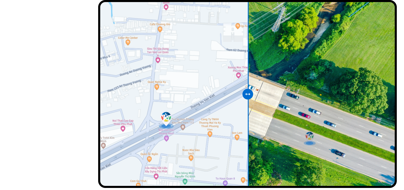
Geographic data is constantly changing, so our system continuously updates the latest information to ensure accuracy.
In addition, we provide tools to help businesses easily manage and organize their geographic data. This includes access control and data management capabilities.
Information security is our top priority, so features such as data encryption, access control, and permission management are integrated to protect your business’s geographic data.

We transform raw data into accurate maps, standardize addresses, remove duplicates, and fix location errors so you can trust every geographic decision.
Supports export to GeoJSON, Shapefile, KML, CSV and easily integrates with your internal system or API. Periodic data updates and customizable layers: routes, POI, administrative boundaries.
Suitable for transportation businesses, location-based apps, real estate, and government agencies, helping reduce costs and enhance user experience.
Customization & Integration on Demand
Multi-platform support
Easy integration
Flexible customization
Standardized formats
Geographic data is constantly changing, so our system continuously updates the latest information to ensure accuracy.
In addition, we provide tools to help businesses easily manage and organize their geographic data. This includes access control and data management capabilities.
Information security is our top priority, so features such as data encryption, access control, and permission management are integrated to protect your business’s geographic data.
For Businesses
Most cost-effective
Updated data, optimized efficiency
Flexible customization
Data security

Whenever someone asks how TrackAsia operates its map system, they usually expect a grand answer: ...
Over the years, OpenStreetMap (OSM) has become one of the most critical open-source geographic da...

In a context where transportation costs and delivery pressure continue to rise, many SMEs in Viet...
Low-code and automation have become popular choices for Vietnamese startups during the MVP stage,...
North–South Expressway Connected from Cao Bang to Ca Mau: Vietnam’s Transportation Map Enters a N...
As 2025 comes to a close, TrackAsia would like to sincerely thank our community of customers, dev...
When Vietnam’s administrative boundaries undergo major changes in 2025, what worries businesses i...

Digital maps today are no longer just tools for displaying location — they have become essential ...

The "A80 Proud Vietnam" app from Hanoi People's Committee helps users follow the parade route.

Many users reported that when accessing VNeID, the app displayed the error: "System under maintenance. Please try again later."

Alibaba launched a new open-source speech-to-video model, allowing the creation of digital avatars that can speak.

ChargePoint introduces a new platform supporting EV charging with power up to 3 megawatts.

Following the success of Tandem OLED screens on the new iPad Pro, LG Display is actively lobbying Apple.
Whenever someone asks how TrackAsia operates its map system, they usually expect a grand answer: dozens of architectural layers, a jungle of the latest technologies, and endlessly complex diagrams....
06/07/2026
Over the years, OpenStreetMap (OSM) has become one of the most critical open-source geographic data platforms in the world. With its open approach, vast community contributors, and high customizabi...
04/07/2026
In a context where transportation costs and delivery pressure continue to rise, many SMEs in Vietnam are turning to Transportation Management Systems (TMS) combined with digital maps and location A...
09/03/2026
Low-code and automation have become popular choices for Vietnamese startups during the MVP stage, thanks to their ability to shorten development time and reduce initial engineering costs. In most b...
20/01/2026
North–South Expressway Connected from Cao Bang to Ca Mau: Vietnam’s Transportation Map Enters a New PhaseIn the final days of 2025, Vietnam’s transport infrastructure reached a historic milestone:t...
24/12/2025
As 2025 comes to a close, TrackAsia would like to sincerely thank our community of customers, developers, and enterprises for their trust and continued partnership in developing digital mapping pla...
23/12/2025
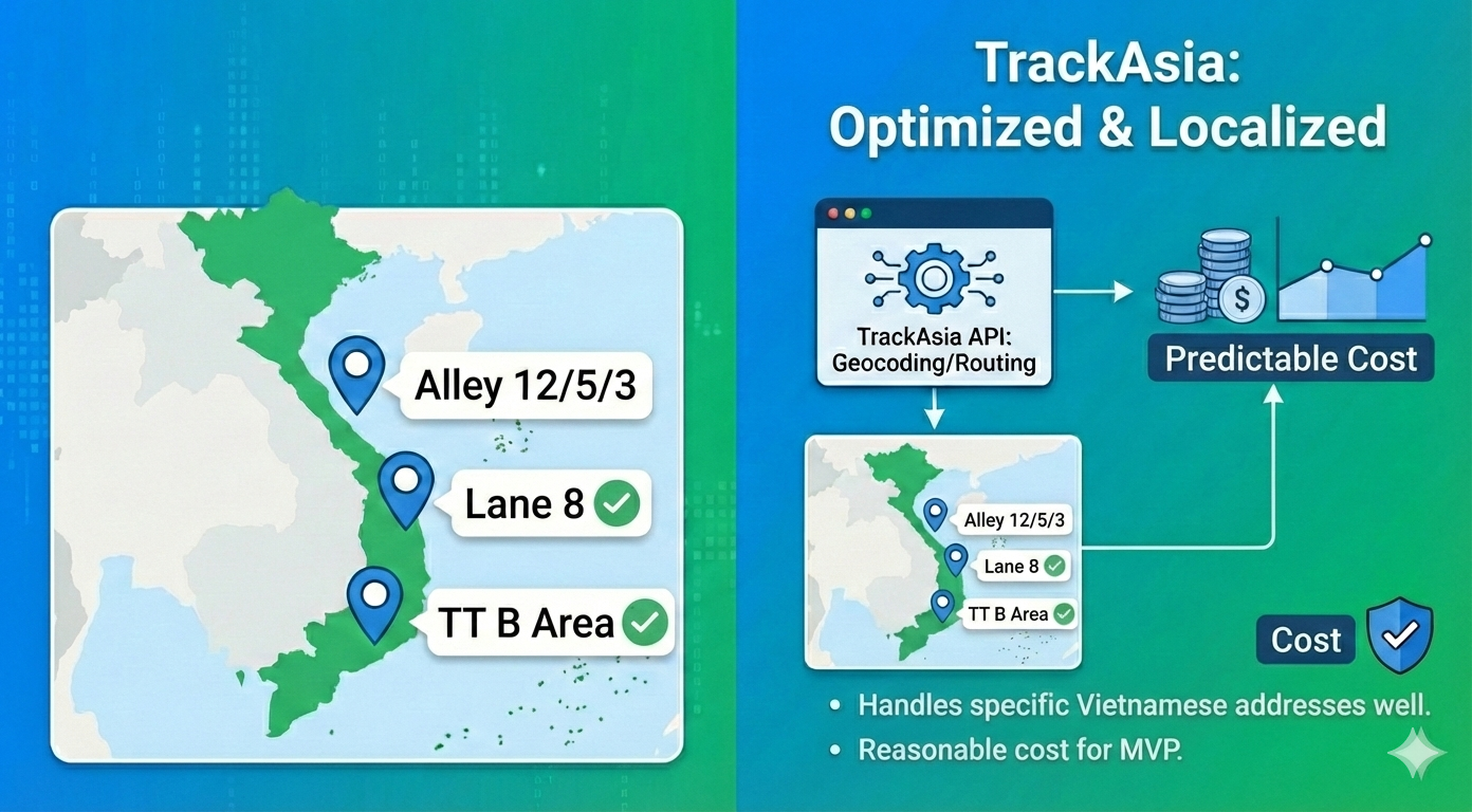
When Vietnam’s administrative boundaries undergo major changes in 2025, what worries businesses is not only data inaccuracy but also the chaos in operations, delivery, and order processing. Familia...
04/11/2025
Digital maps today are no longer just tools for displaying location — they have become essential infrastructure for digital transformation, especially in industries like e-commerce, logistics, real...
15/09/2025
Thank you for trusting TrackAsia solutions


TrackAsia provides comprehensive map APIs including: Autocomplete (address suggestions), Search/Geocoding, Reverse Geocoding, Directions/Routing, Distance Matrix and Vehicle Routing Problem (VRP). These APIs help process addresses, find routes, calculate distances and optimize routes for multiple points or vehicles.
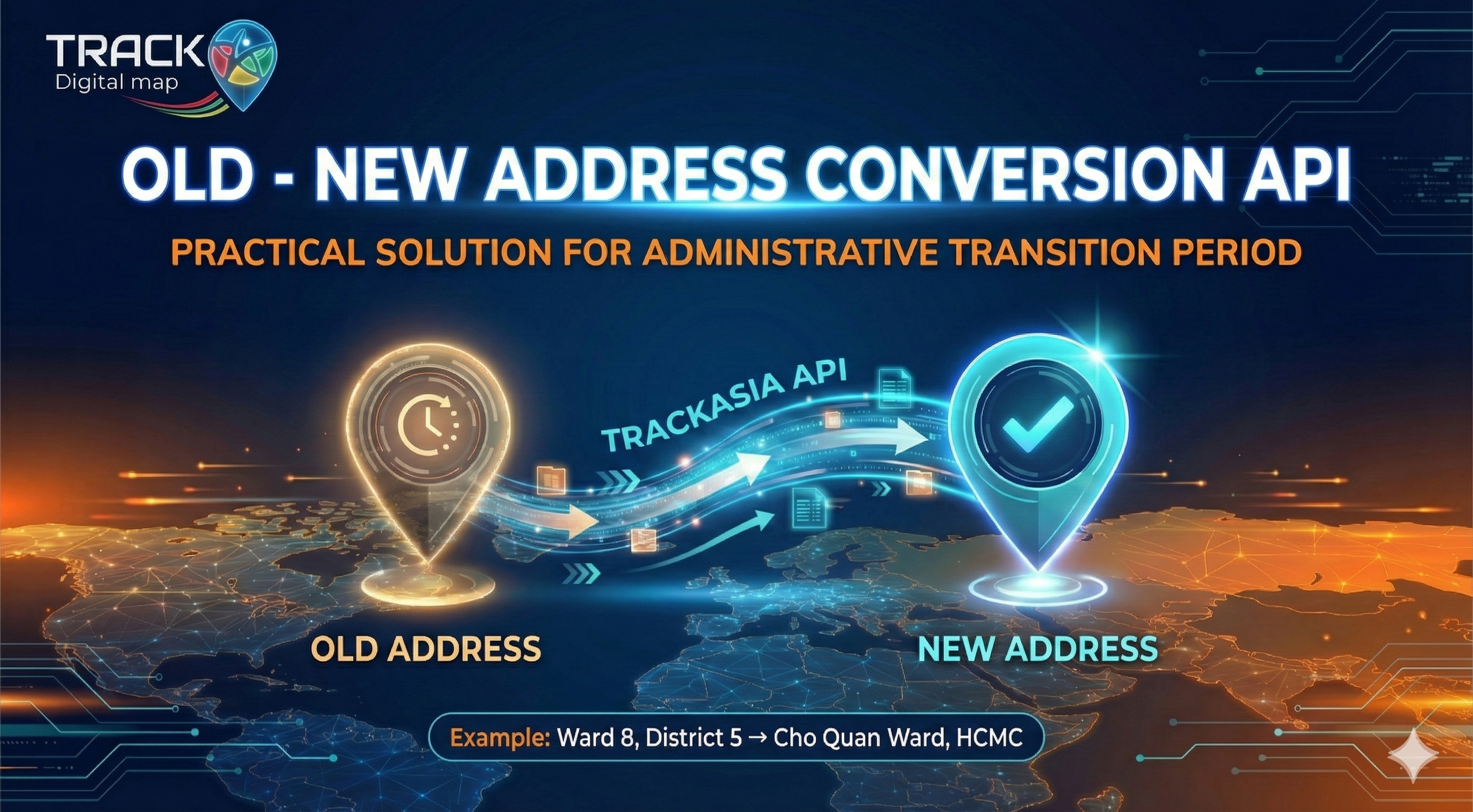
Yes. From July 1, 2025, TrackAsia has updated the new administrative boundaries. Users can add the parameter new_admin=true to receive new addresses, or new_admin=true&include_old_admin=true to display both new and old addresses side by side.
TrackAsia API/SDK supports most popular current platforms such as: Web, React, Flutter, iOS, Android. This ensures easy integration and flexibility for developers on the platforms and languages they use.
TrackAsia offers reasonable costs, data optimized for Vietnamese addresses and traffic, and fast response times thanks to servers located in Vietnam. In addition, our technical team is ready to support, providing more flexibility compared to international map services.
Yes, the API is designed to be compatible and easy to migrate from other providers.
Yes, statistics track traffic, query volume, and usage by day and by month.
There are absolutely no hidden fees. Prices are publicly listed and transparent. You only pay for what you use—no setup fees, no cancellation fees, and no other additional charges.
There is no minimum requirement for the Pay-as-you-go plan. For subscription plans, you can start with plan M1 at 100,000 requests/month. Unused requests do not carry over to the next month.
TrackAsia APIs support JSON (default), XML, and GeoJSON. All APIs follow REST standards and integrate easily with popular programming languages such as JavaScript, Python, PHP, Java, and .NET.
When exceeding quota, the system will send alerts via email when you have 10% remaining. You can choose: (1) Automatic payment, (2) Pause API and continue next month, or (3) Contact us to upgrade your plan or purchase additional quota at a preferential price.
All TrackAsia APIs use HTTPS with TLS encryption. We provide API key authentication, IP whitelisting, and support OAuth 2.0 for enterprise. Data is not stored or shared with third parties.
It's very simple: (1) Register a free account, (2) Get your API key from the dashboard, (3) Test with 3,000 free requests, (4) Integrate into your application. The whole process takes only 10–15 minutes.

Quick sign-up — automatic activation, try now with free credit.
 Vietnamese